
High Plains Road Extension Project
Draft Environmental AssessmentVirtual Public Information Forum
Thank you for visiting the Virtual Public Information Forum website for the High Plains Road Extension Project Draft Environmental Assessment (EA).
The Federal Highway Administration (FHWA) and the Wyoming Department of Transportation (WYDOT) in cooperation with the City of Cheyenne (City) are proposing to extend High Plains Road east from Interstate 25 (I-25) to Parsley Boulevard to complete the east-west connection from I-25 to U.S. Highway 85. This extension would complete the High Plains Road corridor designed to improve regional connectivity, accommodate increased business and residential development, and establish a direct connection to I-25 at the existing High Plains Road Interchange. The interchange features a roundabout at the I-25 ramp termini and is strategically located on a topographic high point, allowing for the future extension of the corridor eastward, including a potential overpass across the adjacent Burlington Northern Santa Fe (BNSF) rail line.
The FHWA is serving as lead federal agency for the proposed High Plains Road Extension (Project) in coordination with WYDOT as state partner and the City as the Project proponent. This Draft Environmental Assessment (EA) complies with the National Environmental Policy Act of 1969 (NEPA) and the FHWA NEPA Implementation Laws and Regulations (2025). The Draft EA evaluates the potential impacts associated with the proposed Project and considers reasonable alternatives, in accordance with the NEPA and applicable federal, state, and local regulations.
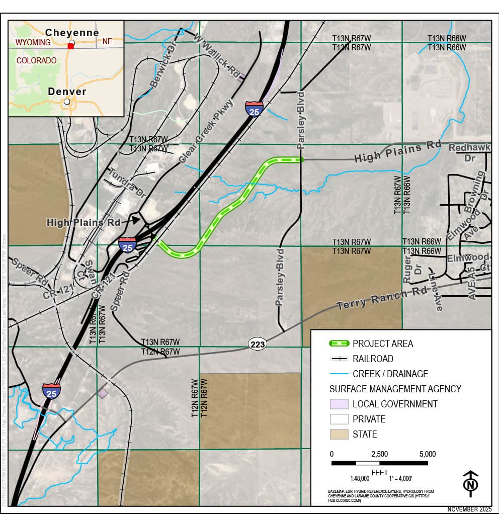
Figure 2-2 EA Proposed Action Location Map dated November 2025, showing the High Plains Road Extension Project area in Laramie County, Wyoming. The project area is highlighted in green hatched pattern, running generally east-west just south of High Plains Road and north of Terry Ranch Road, starting west of Parsley Boulevard and extending eastward. Key transportation features include Interstate 25 (I-25) running north-south through the western portion with the High Plains Road Interchange, High Plains Road extending east-west from I-25, Terry Ranch Road running east-west south of the project area, State Highway 223 in the lower section, Parsley Boulevard running north-south parallel to I-25, and numerous local roads including W Wallick Road, Berwick Drive, Clear Creek Parkway, Tundra Drive, Speer Road, County Road 121, Swan Road, Redhawk Drive, Browning Drive, and various Elmwood and Ruger streets. A Burlington Northern Santa Fe (BNSF) railroad line runs parallel and east of I-25, crossing High Plains Road and Terry Ranch Road. Blue lines indicate creeks and drainage systems, including one flowing under Clear Creek Parkway and I-25, and others in the western and southeastern sections. Land ownership is color-coded with light purple for local government, light gray for private land, and light brown/tan for state land. An inset map in the top left corner shows the regional context with Cheyenne, Wyoming and Denver, Colorado. The map includes township and range grid coordinates (T13N R67W, T12N R67W, T13N R66W, T12N R66W), a scale bar indicating 1:48,000 scale (1 inch equals 4,000 feet), a compass rose pointing north, and source information noting the basemap uses ESRI Hybrid Reference Layers and hydrology from Cheyenne and Laramie County Cooperative GIS.